Buffalo was at one point a colossal American city, making the top ten by population in the country for two decades a century ago. But since then it has declined: both in a relative sense to to 45th place, and in an absolute sense losing over half its city population since 1950 and falling as a metro region since too since 1970. The rapid transit system also disintegrated, with rail routes disappearing from the '30s to 1950, though a single light rail system made its debut in the '80s.
This transit map focuses many of the routes along the river/lake to connect with the light rail line downtown at Exchange St. I've also added a new light rail station at Parkside to intersect the new Green Line. The system provides connections to Amtrak at three stations, and gets close enough for a workable transfer to both of the region's airports.
Thursday, December 17, 2015
Tuesday, December 1, 2015
Columbus
This system of half a dozen lines contributes to the dreamed-of mobility of Ohio's capital and largest city. The convergence of lines downtown misses the core central business district by a few blocks, but does hit several redeveloping locations along the riverfront. There aren't many long-distance connections here, since the lines don't get close enough to the main commercial airport and there's no regional rail system in the city (apparently, Columbus is the 3rd largest U.S. city without Amtrak).
Tuesday, October 27, 2015
Orlando
Orlando could conceivably be considered an extension to the Tampa system, but instead is presented as its own system, with a connection to Tampa's regional rail at Lakeville. In addition, it provides connections to four Amtrak stations, plus the airport (via a shuttle).
Tuesday, October 20, 2015
Minneapolis - St Paul
The Twin Cities of Minneapolis and St Paul house the capitol building along with two-thirds of all Minneapolis residents in their metro area. A light rail line has connected Minneapolis with the airport since 2004, and a second linked the two downtowns a decade later. Minneapolis is also linked to its northwestern suburbs by the Northstar Commuter Rail. But for such a large city with fairly thorough existing rail property, more is possible.
South of the Savage / Port Cargill area, there's a right-of-way which is intact, but definitely lacking any hardware. If we're rebuilding anyway, I've decided to make that a feeder Bus Rapid Transit line, connecting Lakeville to a new transit center at Savage.
South of the Savage / Port Cargill area, there's a right-of-way which is intact, but definitely lacking any hardware. If we're rebuilding anyway, I've decided to make that a feeder Bus Rapid Transit line, connecting Lakeville to a new transit center at Savage.
Wednesday, October 7, 2015
Nashville
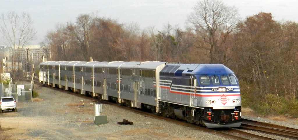
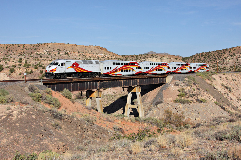
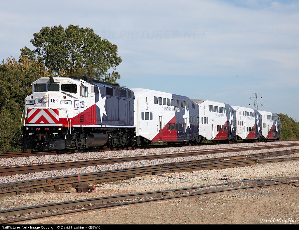
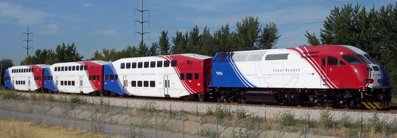
In Tennessee's capital, we've come across a city with an existing commuter rail system: the oft-maligned Music City Star. As I built my system out, it seemed that this existing route was laid through one of the less populated rail corridors available, which probably goes to show there's more to making a network than looking where there's existing train tracks.
The station spacing on the Music City Star to Lebanon is far wider than the 1 to 3 miles I typically use. This may be due to the sparser population to the east, or that this (and as we'll see with other upcoming cities with existing heavy rail) is more of a "park-and-ride" system, whereas mine are design to support/encourage walkable communities around the stations.
We now also have an idea as to what rolling stock might be used: a diesel locomotive with a couple of double-deck cars behind.

from Peepersk
This in fact is an incredibly popular decision, it turns out, for isolated commuter rail systems. The Nashville Star, Virginia Railway Express, New Mexico Rail Runner, Minneapolis Northstar, Dallas Trinity, Florida TriRail, Utah Frontrunner, and Seattle Sounder all have something similar. I've always been planning on using diesel, since I don't expect cities to install catenaries. But for the closer-spaced stations, I think DMUs (like Austin or Denmark) would work better.
Lines
- Green: 62.4 miles, 26 stations
- Purple: 23.4 miles, 13 stations
- Red: 41.2 miles, 22 stations
- Yellow: 22.7 miles, 11 stations
- Music City Star: 31.1 miles, 6 stations
Friday, October 2, 2015
Richmond
Virginia's capital has a metropolitan population of just over a million. It is well-served by Amtrak, but lacks any regional rail system; the Virginia Railway Express to Washington ends 60 miles to its north. This Dreamed-Of system provides connections to three Amtrak stations and even a walking-distance link to the airport.
Lines
- Orange: 20.7 miles, 13 stations
- Purple: 29.9 miles, 17 stations
- Yellow: 17.7 miles, 10 stations
- Cyan: 19.7 miles, 11 stations
- Green: 41.7 miles, 19 stations
Tuesday, September 29, 2015
Birmingham
Alabama's largest city, Birmingham currently doesn't have any rapid transit system (though a downtown streetcar has been proposed). The metro area population of over 1,100,000, with large population spread throughout the connected regional towns. The dreamed-of system has five lines which converge on the downtown station, which also provides connection to Amtrak with service to New Orleans, Atlanta, Washington, and New York.
Lines
- Yellow: 39.8 miles, 17 stations
- Red: 24.5 miles, 15 stations
- Cyan: 29.2 miles, 14 stations
- Violet: 18.5 miles, 11 stations
- Orange: 42.3 miles, 19 stations
Wednesday, September 23, 2015
Tampa
The Tampa Bay Area, including Tampa, Clearwater, and St Petersburg, is home to over 4 million people, and represents another colossal urban complex without any existing rapid transit (barring the heritage TECO streetcar line). Its six lines provide connections to two Amtrak stations, as well as the Orlando regional rail system (coming soon).
Lines
- Light Blue: 77.8 miles, 29 stations
- Orange: 56.2 miles, 16 stations
- Green: 47.9 miles, 12 stations
- Navy: 14.8 miles, 10 stations
- Lavender: 59.5 miles, 14 stations
- Yellow: 59.8 miles, 19 stations
Monday, September 14, 2015
Houston
Houston is the largest city I've tackled with over 6 million people in the metropolitan region, which really means it's the largest in the country without a major metro system. This is changing however, with its first light rail line in 2013, and two smaller routes opening earlier this year. The extensive existing train tracks also made for an impressive dreamed-of system, with five lines and over 100 stations.
Houston's Amtrak station is served by the yellow and cyan lines, and all lines have transfers to the light rail system at at least either University Downtown or Eado Transfer, as indicated by the MetroRail icons [I added an additional light rail station at Fulton transfer]. This time, I did build in shuttle buses to connect Houston's two airports to nearby rail lines.
Houston's Amtrak station is served by the yellow and cyan lines, and all lines have transfers to the light rail system at at least either University Downtown or Eado Transfer, as indicated by the MetroRail icons [I added an additional light rail station at Fulton transfer]. This time, I did build in shuttle buses to connect Houston's two airports to nearby rail lines.
Lines
- Blue: 57.7 miles, 22 stations
- Cyan: 66.3 miles, 26 stations
- Yellow: 46 miles, 18 stations
- Lavender: 82.2 miles, 28 stations
- Green: 73.3 miles, 23 stations
Saturday, September 12, 2015
Indianapolis
This scheme gives a transit system to Indiana's capital and largest city. Like Norfolk, one of the lines borders the non-terminal side of the airport and so is close, but lacks a connection. The city center station also serves Amtrak's long-distance lines, with daily service to Chicago and three trains a week to Washington and New York.
Lines
- Blue: 39.9 miles, 21 stations
- Cyan: 33.3 miles, 23 stations
- Red: 35.5 miles, 23 stations
- Pink: 26 miles, 14 stations
- Black, 44 miles, 31 stations
Raleigh
The Raleigh regional rail system connects Raleigh with Cary and Durham, as well as many of the office parks in this "Research Triangle" region. There are also five universities served by the system, and connection to long-distance rail at three Amtrak stations.
Lines
- Orange, 26.7 miles, 13 stations
- Blue, 55.4 miles, 31 stations
- Black, 25.5 miles (including Durham loop, runs clockwise), 17 stations
- Red, 35.9 miles, 26 stations
- Yellow, 17.7 miles, 11 stations
Norfolk
The Norfolk system serves many of the connected cities in Virginia's largest metropolitan region. Shame there isn't a connection across the James River to Newport News. The new rail system provides an interchange with the existing Tide Light Rail system at Harbor Park, where there is also a connection to Amtrak's recently added Norfolk service. While the Orange Line does border the edge Norfolk's airport, it's opposite the terminal and wouldn't provide convenient access.
Lines
- Tide Light Rail (Blue, diamonds on the interactive map): 7.3 miles, 11 stations
- Yellow: 14.5 miles, 10 stations
- Orange: 29.2 miles, 13 stations
- Green: 17.5 miles, 7 stations
- Cyan (Crosstown): 16.2 miles, 12 stations
Madison
Madison was one of last systems to plan, but the first to create a schematic map for. Its natural 45-degree angle paths along and above the isthmus lent themselves nicely to the diagram format. It's also one of the smaller networks, serving a metro area of 627,00 people.
Madison has a great convergence of lines downtown just a quarter mile from the capitol building. The Green Line has a stop within walking distance of the airport terminal, though Madison lacks an Amtrak station to make long-distance rail connections (thanks, Scott Walker!).
Lines
- Blue: 18.5 miles, 12 stations
- Green: 17.7 miles, 10 stations
- Purple: 15.0 miles, 9 stations
- Red, 19.5 miles, 15 stations
Introduction
Welcome to the blog. I've looked over maps of many of the largest cities in the U.S. which have little or no rapid transit, and carved out some possibilities for them. Here are the rules/notes:
- Existing train tracks. All the new routes only use currently developed rail lines. Many of these may be active (or occasional) freight routes, which adds expense by the added complications to comply with the FRA shared track requirements. However, this is more than made up by using existing right-of-ways and minimizing tunnels, elevated lines, and land acquisition.
- Mile spacing. Stations are at least one mile from their neighbors on the same line, except in the city center, where they can be as close as half a mile.
- Through-running trains. Whenever possible, the lines pass through the city center rather than terminating in the core. This allows for reverse- and through-commuting and minimizing storage yard requirements in locations where there is the least room.
- Station colors. White with black circle stations service more than one line. Extra large stations are either city centers or major transfer points. Solid colored circles are served by a single line during all operating hours. Small white circles with colored backgrounds are for outlying communities and are served only during peak hours. Tick marks are existing (in real life) light rail stations.
- Line colors. Mostly anything goes, with a fair amount of whim and chance. But there are 2 rules: black lines are used where the right-of-way is intact (or nearly so), but the tracks are missing or impassible, and so would require a bit more to get up to working order; grey lines are used for an existing (in real life) commuter rail system.
Subscribe to:
Posts (Atom)